Common name: Pink Five-Corners
Styphelia triflora Andrews APNI* 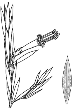
Description: Erect diffuse to bushy shrub 0.4–2 m high; branchlets glabrous or rarely scabrous.
Leaves mostly elliptic to oblong-elliptic (young seasonal growth leaves obovate or oblanceolate), 14–33 mm long, 3–8.5 mm wide, acute; margins usually entire; upper surface flat to concave; petiole 2–4 mm long.
Flowers spreading to drooping, usually pink to red but occasionally cream or pale yellow-green; bracteoles 2.8–5.6 mm long, glabrous. Sepals 8.2–13.4 mm long, glabrous. Corolla tube 13.5–29.4 mm long; lobes 12.5–18 mm long. Filaments 9–17.2 mm long; anthers 3–5 mm long.
Fruit 6.5–8 mm long, finely ribbed.
Flowering: throughout year, mainly April–October
Distribution and occurrence: Widespread in sclerophyll forest and woodland with Casuarina and Callitris, on sandy soils or loams on various substrates; north from Jervis Bay and Queanbeyan.
NSW subdivisions: NC, CC, SC, NT, CT, ST, NWS, CWS, NWP
Other Australian states: Qld
Text by J. M. Powell, except for groups with contributors listed
Taxon concept: Flora of NSW 3 (1992)
ECOLOGY
Life History
Flowers Pink--red or cream or pale yellow-green, mainly April--October, peak September--October.
Fruit/seed Succulent fruit (drupe), 6.5--8 mm long, mature August--May.
Fire response Killed (Bantry Bay 1991, L.McD.), a few seedlings seen within 15 months of high intensity fire (at Lane Cove River & Narrabeen Lake 1/1994, P. Kubiak pers. comm.).
Habitat
Habitat Sandstone ridge, moist gully.
Altitude 0--1200 mm
Annual rainfall 700--1400 mm
Typical local abundance Frequent--occasional.
Vegetation Eucalypt forest and woodland e.g. with Angophora costata, Eucalyptus piperita, E. rossii, E. mannifera, E. macrorhyncha, E. dives. Sea cliff-top scrub e.g. with Melaleuca nodosa, Leptospermum laevigatum, Calythrix tetragona.
Substrate Sandy--clayey soils on sandstone, conglomerate, low nutrients.
APNI* Provides a link to the Australian Plant Name Index (hosted by the Australian National Botanic Gardens) for comprehensive bibliographic data
***The AVH map option provides a detailed interactive Australia wide distribution map drawn from collections held by all major Australian herbaria participating in the Australian Virtual Herbarium project.
|