Helichrysum calvertianum (F.Muell.) F.Muell. APNI* 
Description: Twiggy subshrub to 30 cm high, much-branched; stems glabrescent with sparse woolly and minute glandular hairs, the lower leaves caducous leaving prominent scars.
Leaves crowded, linear, 3–8 mm long, 0.5–0.8 mm wide, margins revolute and concealing the lower surface, surfaces green and glabrous, viscid.
Heads terminal and solitary on branches, hemispherical, 0.7–1 cm long, 1–1.5 cm diam.; involucral bracts with margins woolly-ciliate towards base, laminas reflexed at maturity; intermediate bracts longest with white papery laminas often tinged pink towards the apex, outermost bracts golden and hyaline, innermost with long claws and with small white papery laminas. Florets numerous, all bisexual.
Achenes oblong, terete, minutely glandular; pappus of many barbellate bristles, subplumose at the tip.
Flowering: winter–summer.
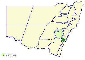
Distribution and occurrence: Only known from Hawkesbury Sandstone in dry sclerophyll forest and associated mallee and heath. Restricted to the Southern Highlands region between Joadja, Belanglo, Canyonleigh (east), Penrose, Paines Lookout (Fitzroy Falls locality), the northern edge of Mt Gibraltar Heritage Reserve, Welby, and Berrima. A collection from Tallong is spatially dubious though there is potential habitat in that locality. References to Mt Jellore Lookout in the Mt Gibraltar area may be misleading as the species is not known to occur on microsyenite – these records relate to a population in the north of that Reserve on uplifted Hawkesbury Sandstone.
NSW subdivisions: CT
Threatened species: NSW BCA: Vulnerable; Commonwealth EPBC: Vulnerable
Text by J. Everett; updated L. Murray, A. Orme with habitat information supplied by S. Doulgas, Feb 2025.
Taxon concept: Flora of NSW 3 (1992)
APNI* Provides a link to the Australian Plant Name Index (hosted by the Australian National Botanic Gardens) for comprehensive bibliographic data
***The AVH map option provides a detailed interactive Australia wide distribution map drawn from collections held by all major Australian herbaria participating in the Australian Virtual Herbarium project.
|


%20(1%20of%201).jpg)